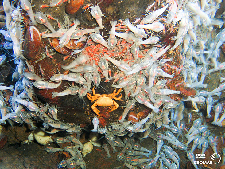
Megafauna in deep-sea hydrothermal systems

The aim of the biodiversity project is to characterise benthic communities in the area north of the Rodriguez-Triple Junction (south central Indian Ridge) and along the southeast Indian Ridge. Species composition, as well as distribution patterns and dependence on environmental variables, will be investigated to identify and analyse abiotic factors relevant to biodiversity conservation in abyssal hydrothermal fields. For this purpose, video and photographic sequences will be recorded, which will provide information on the distribution of species communities and their composition of active and inactive hydrothermal fields, as well as of the adjacent abyssal plains.
Based on these data, the communities are differentiated and biotope maps for the region are developed. The comparison of the species communities of different hydrothermal fields will provide a better understanding of the ecology and biogeography of these habitats in the Indian Ocean. The biological evaluation is a sub-project of the INDEX project of the BGR (Federal Institute for Geosciences and Natural Resources) for the exploration of massive sulphide deposits for the Federal Republic of Germany.

The use of image and video material to record fauna in deep-sea plains is a form of non-invasive data collection in marine ecology that has been increasingly used in recent years. This involves the targeted use of transects with cameras pointed vertically at the seabed and the continuous recording of contiguous areas with high-resolution video cameras and cameras. Processing these enormous amounts of data requires post-processing in photo and video editing programs, as well as evaluation in so-called photo mosaic and annotation programs. In the process, coherent, georeferenced image mosaics are created that contain the location, the image section captured by the camera, the direction and the distance. In addition, 3D reconstructions can be created from the processed images, producing both a high-resolution photomosaic of the seabed and a detailed topographic map with the abiotic factors derived from it for biological evaluation.
The use of these programmes enables an area-wide, precise evaluation of video and photo material as well as a transfer of these data into GIS-based maps. A major advantage of this method is that the data collection does not interfere with the sensitive deep-sea ecosystem. This means that, among other things, monitoring projects can also be established in small-scale biotopes such as the hydrothermal fields without disturbing or permanently altering them.
(The present images and videos originate from the INDEX exploration project for marine polymetallic sulphides by the Federal Institute for Geosciences and Natural Resources (BGR) on behalf of the German Federal Ministry for Economic Affairs and Energy. Exploration activities are carried out in the framework and under the regulations of an exploration license with the International Seabed Authority. BGR has to be notified of any scientific and public use of the material and acknowledged accordingly.)

